The significance of the postcard was mainly that it provided a nice illustration to the diagram of the (1891-1926) sea wall in that article in the Structural Engineer:
Being a little selective now, aren't we?

What you
actually said was...
And here we have an interesting picture, which I would tentatively date to the 1930s (car, dress ...), of just that stretch of sea wall, if I'm not mistaken. With a little digging and a few sandbags, the clay bank could have been made into a good defensive position. Not over the whole length of course, if the defense was based on "Forward Defended Localities" manned at platoon strength - as it no doubt was - there would have been gaps of several hundred yards between such positions (I'll have to calculate that a bit more precisely later on), with barbed wire and perhaps a double line of the famous Beach Mines in between
Strangely - no mention of the article in the
Structural Engineer...

And I did not say that the 7th SLI was digging in at that particular point, you're being deliberately obtuse again ...
And YOU are being deliberately disingenuous
Noone was talking about that particular
POINT in the picture, but in fact about digging in
as you described above in the clay bank behind the 19th/early 20th century stone and concrete improvements
When challenged on THAT aspect, you replied quite specifically -
As decribed in, for example, the WD of the 7th SLI that I quoted a few pages back, who spent a couple of weeks doing just that.
As for this -
I only referred to the WD of the 7th to show that there was a lot of digging, sandbagging, wiring and mine laying going on.
...you seem to be choosing to forget that your reply was in answer to something specific I challenged...
Have you perhaps researched how the medieval sea wall was built? To dig dugouts/rifle pits....AND holes for a double line of (quite large) mines is going to take a LOT of digging.
As decribed in, for example, the WD of the 7th SLI that I quoted a few pages back, who spent a couple of weeks doing just that.
Perhaps you would be so kind as to explain exactly what it is you are trying to argue? That digging holes was beyond the capablities of the British army at the time? Or that quite naturally they would have dug in somewhere where they couldn't see anything and couldn't bring their weapons to bear?
It's quite simple, really...and given the time that has elapsed and the couple of times I queryed it, one might have expected you to
check... :roll:
As mentioned previouisly, the war diary of the 7th SLI does NOT support your citing it in defence of your ideas that "...the clay bank could have been made into a good defensive position." Because the only place it even mentions digged/establishing positions on the "sea front"...
There WAS no clay bank or improved sea wall!
The Dymchurch Wall STOPS at Littlestone - the war diary uses the term "sea front" to describe the location of the activities of the 27th to finish then test
A Company's section of the defences up to the Right Boundary I.E.
Greatstone...
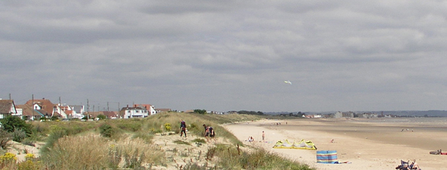
You can even just about make out the end of the sea wall in the distance, at
Littlestone-on-Sea; but at Greatstone, the "sea front" is just sand dunes.
One would have thought that since YOU were the one who brought
THIS map to the thread -

- you might have realised where the Dymchurch Wall
stopped...
Twenty years ago we had Johnny Cash, Bob Hope and Steve Jobs. Now we have no Cash, no Hope and no Jobs....
Lord, please keep Kevin Bacon alive...
