Seelöwe - German & British mining operations

Discussions on WW2 in Western Europe & the Atlantic.
Post Reply
User avatar
LWD
Member
Posts: 8618
Joined: 21 Sep 2005, 22:46
Location: Michigan

Re: Seelöwe - German & British mining operations

#121

Post by LWD » 24 Apr 2013, 18:02

Juha Tompuri wrote: ...
It even seems that quite many RN destroyers could pass the EMG mine fields unharmed.
...
If this was in reference to the Sea Lion mine fields. Which destroyers are those and why?
It doesn't look like having the mines set to a depth of 9m will allow that.
At least not for the the V&W classes which drew 3.4+m at full load.
Possibly the Towns but not many were operational at that point and I'm not sure a draft of 2.7m insures them against mines at that depth.
Not the A class or the B class either which drew 3.7+m
Or the C, D, E, F, G, H, I, K or M classes which had a draft of 3.8+m
Now the L and M classes only had a draft of 3m but that doesn't mean they are safe vs these mines either.
The Tribals and the O and P classes had a draft of 2.7 but I'm pretty sure that's standard and not full load and again given the effects of wind, current, and wave hardly insures their safety.

User avatar
Juha Tompuri
Forum Staff
Posts: 11563
Joined: 11 Sep 2002, 21:02
Location: Mylsä

Re: Seelöwe - German & British mining operations

#122

Post by Juha Tompuri » 24 Apr 2013, 19:21

LWD wrote:
Can we have an answer to this:
Juha wrote:
LWD wrote:
Juha Tompuri wrote: Still wonder where you got the 2,5/2,50m floating depth that seemed to have been the problem to you. At least not from my posts.
Because your initial post on the topic made it look like you considered the difference between 8ft and 2.5m significant.
Could you please point out what post of mine you mean?
Regards, Juha
Given the Phylo had previously refered to the fact that 8 feet was not an exact conversion of 2.5m and the following could be taken that way:
Juha Tompuri wrote:
phylo_roadking wrote:now, looking at the description of the EMG mine assembly that I and LWD have linked to...

Height regulated to eight feet below surface level by the float...
According to this info, seems to be not so:
http://www.minenjagd.de/minenjagd/minen ... en/emg.php

Regards, Juha
Now if you had come out and stated that it was 3m all would have been clear.
But...You just have posted that you had understood from the drawing at that site that the EMG mine floated at 3m.
What's the problem then?

Anyway, after that I posted two posts clarifying the matter:
Juha Tompuri wrote:
phylo_roadking wrote:You are quite correct; "2,5 Meter" is actually 8 feet 2 and 27⁄64 inches...
Yes, you seem to have understood the float cable lenght correct...
...but the EMG mine floated even more deep than that, if you look at the drawing attached.
In addition of the cable there is also the float.
and:
Juha Tompuri wrote:
Juha Tompuri wrote:
phylo_roadking wrote:You are quite correct; "2,5 Meter" is actually 8 feet 2 and 27⁄64 inches...
Yes, you seem to have understood the float cable lenght correct...
...but the EMG mine floated even more deep than that, if you look at the drawing attached.
In addition of the cable there is also the float.
In other words the mine floating slightly under ten feet depth (3 meters) and the mine horns slightly deeper, perhaps a bit over ten feet depth.

So... it was after I had posted that the mine floated at 3m depth you came in with your own agenda.

The most recent claim being:
[quote="
LWD wrote:if you had come out and stated that it was 3m all would have been clear.
Regards, Juha
Last edited by Juha Tompuri on 24 Apr 2013, 20:32, edited 1 time in total.
Reason: adding info


User avatar
LWD
Member
Posts: 8618
Joined: 21 Sep 2005, 22:46
Location: Michigan

Re: Seelöwe - German & British mining operations

#123

Post by LWD » 24 Apr 2013, 21:40

Juha Tompuri wrote: But...You just have posted that you had understood from the drawing at that site that the EMG mine floated at 3m.
What's the problem then?
Because I didn't realize that was your point and so we spent a fair amount of time and text devoted to a non issue.


Anyway, after that I posted two posts clarifying the matter:
Juha Tompuri wrote:
phylo_roadking wrote:You are quite correct; "2,5 Meter" is actually 8 feet 2 and 27⁄64 inches...
Yes, you seem to have understood the float cable lenght correct...
...but the EMG mine floated even more deep than that, if you look at the drawing attached.
In addition of the cable there is also the float.
and:
Juha Tompuri wrote:
Juha Tompuri wrote:
phylo_roadking wrote:You are quite correct; "2,5 Meter" is actually 8 feet 2 and 27⁄64 inches...
Yes, you seem to have understood the float cable lenght correct...
...but the EMG mine floated even more deep than that, if you look at the drawing attached.
In addition of the cable there is also the float.
In other words the mine floating slightly under ten feet depth (3 meters) and the mine horns slightly deeper, perhaps a bit over ten feet depth.

So... it was after I had posted that the mine floated at 3m depth you came in with your own agenda.
Not an agenda at all. I misunderstood your point and replied based on that misunderstanding.
The most recent claim being:
[quote="
LWD wrote:if you had come out and stated that it was 3m all would have been clear.
You have a problem with that?
In anycase we are no longer dicussing WWII material so I'll try and confine my responses to that.

User avatar
Juha Tompuri
Forum Staff
Posts: 11563
Joined: 11 Sep 2002, 21:02
Location: Mylsä

Re: Seelöwe - German & British mining operations

#124

Post by Juha Tompuri » 24 Apr 2013, 23:30

LWD wrote:
Juha Tompuri wrote: But...You just have posted that you had understood from the drawing at that site that the EMG mine floated at 3m.
What's the problem then?
Because I didn't realize that was your point

LWD wrote:
LWD wrote:if you had come out and stated that it was 3m all would have been clear.
You have a problem with that?
Well not me... as mentioned, I did write that the EMG mine floated at 3m depth and I did post a drawing indicating the same.

But...as there seems to have been no mention that you had understood that the EMG mine floated at mentioned 3m depth, before my posting of the material over and over again, I/we really do now not have any problems understanding how the things went in reality, and so we perhaps can finally leave this sidetrack behind.

Regards, Juha

Capitan Trueno
Member
Posts: 2
Joined: 23 Apr 2013, 23:55

Re: Seelöwe - German & British mining operations

#125

Post by Capitan Trueno » 25 Apr 2013, 19:49

It's worth noting that Franz Halder had a meeting with the Naval Staff during his "birthday" visit back to Berlin at the end of June - specifically on the 1st of July; along with various other points, the Naval Staff discussed that
f) Underwater threats can be neutralized by net barrages. Surface threats can be minimized by mines and submarines supplementing land-based Arty and planes.
Note the difference in nomeclature here; the Kriegsmarine did not not forsee mines fully closing the Channel...only "minimizing" the risk to the invasion.

http://cgsc.contentdm.oclc.org/utils/ge ... e/3977.pdf document page 99.

User avatar
LWD
Member
Posts: 8618
Joined: 21 Sep 2005, 22:46
Location: Michigan

Re: Seelöwe - German & British mining operations

#126

Post by LWD » 29 Apr 2013, 15:53

Have you seen anything to indicate that the Germans had the capability to put the "net barrages" in place? Some of the info presented earlier in this thread certainly raises the question of whether or not the mine barrages were feasable during the required time frame.

Knouterer
Member
Posts: 1663
Joined: 15 Mar 2012, 18:19

Re: Seelöwe - German & British mining operations

#127

Post by Knouterer » 08 Jun 2014, 14:13

I don't think there can be any doubt that "floaters" were a serious problem. If we take just the limited stretch of coast that the Folkestone Herald felt bound to report on:

"Wednesday 3 January (1940). the Chief Constable of Kent reported that four mines were washed ashore at Dungeness this morning. These have been rendered harmless.
Thursday 4 January. Kent County Police reported that at 00200 hrs today a mine was washed ashore 100 yds from the at Lade look-out near Lydd.
7 Jan. Two British mines washed ashore near Hythe.
11 Jan. A British mine washed ashore near Greatstone.
14 Jan. Sea mines washed ashore at Dungeness.
29 Jan. Mines washed ashore at Folkestone, Hythe and Dymchurch."
And so on. Of course, this high incidence may have had to do with stormy winter weather.
Last edited by Knouterer on 08 Jun 2014, 15:11, edited 1 time in total.
"The true spirit of conversation consists in building on another man's observation, not overturning it." Edward George Bulwer-Lytton

Knouterer
Member
Posts: 1663
Joined: 15 Mar 2012, 18:19

Re: Seelöwe - German & British mining operations

#128

Post by Knouterer » 08 Jun 2014, 15:07

It is also noticeable, IMHO, that the S-Boote (E-boats) and the RN MTBs suffered significant losses (relative to the number in service at any one time, not more than two dozen or so on either side) from mines in this period. The Germans lost S23 on 11 July and S37 in mid-October. The British lost MTB 15, 16 and 17 in Sept.-Oct. (on three separate occasions).
The relevant literature does not explicitly say so, but in view of the shallow draught of these boats, and the fact that their skippers were probably better informed than most about where the minefields were, I'm inclined to think these losses were due to "floaters", or at least some of them.

All in all, if the Germans had attempted to cross the Channel with 3,000 vessels, I think we can safely assume they would have run into a few floaters on the way - with the consequent disruption of formations as following tugs veered off course and collided, etc.
"The true spirit of conversation consists in building on another man's observation, not overturning it." Edward George Bulwer-Lytton

User avatar
phylo_roadking
Member
Posts: 17488
Joined: 01 May 2006, 00:31
Location: Belfast

Re: Seelöwe - German & British mining operations

#129

Post by phylo_roadking » 08 Jun 2014, 23:24

It is also noticeable, IMHO, that the S-Boote (E-boats) and the RN MTBs suffered significant losses (relative to the number in service at any one time, not more than two dozen or so on either side) from mines in this period. The Germans lost S23 on 11 July and S37 in mid-October. The British lost MTB 15, 16 and 17 in Sept.-Oct. (on three separate occasions).
The relevant literature does not explicitly say so, but in view of the shallow draught of these boats, and the fact that their skippers were probably better informed than most about where the minefields were, I'm inclined to think these losses were due to "floaters", or at least some of them.
S-boats themselves were also being used for fast mining at night by September IIRC. They were encountered doing so a few times. They'd of course be less likely to spot floaters at night...let alone avoid them at speed. Again, it would be worth looking at each individual loss and what the S-boat was actually doing on that sortie... S23 was lost off Calais, S37 east of Orfordness...I.E. check if they weren't actually operating within known minefields (laid by EITHER side) at the time.
All in all, if the Germans had attempted to cross the Channel with 3,000 vessels, I think we can safely assume they would have run into a few floaters on the way - with the consequent disruption of formations as following tugs veered off course and collided, etc.
A few, yes - but Schenk notes that this issue of floaters and break-frees WAS recognised by the KM. Hence the development of the EMG mine.

The issue of currents in the English Channel is not as simple as it seems...

Extract from the Admiralty Tidal Stream Atlas for the English Channel...notice anything?

Image

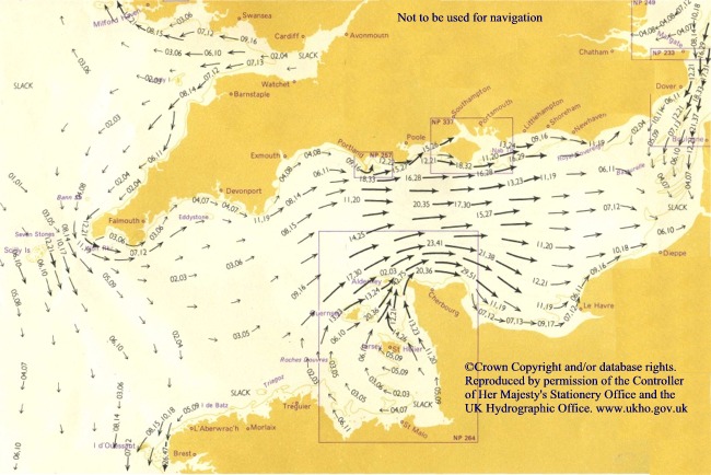
Only fields A1 and A2 were to be laid in the area of the strongest currents ;) By the time you get up-Channel to where the big fields - the 1200-strong B2 and B3 EMG fields - were to be laid, the currents are tapering off sharply. And the EMG was more able to cope with currents along with the rise and fall of the tide...and then there's the "slack" current area from Beachy Head to Dieppe and eastwards for a few miles that would keep the majority of floaters from the down-Channel fields away from the Narrows...

Interestingly - the LAST fields to be laid were the very small B1...and the small C1 and C1A fields just north of the Narrows in that OTHER section of strong currents you can see entering the Narrows from the north end. But they were to be laid as late as S minus 2, so there would be less time anyway for floaters to break free than the A fields or B2 and B3 and both the D fields...

Thus minimising the amount of German floaters that could potentially threaten the First Wave fleets. The KM can't of course do anything about BRITISH-laid mines and British-origin floaters...but they can work with the currents etc. to minimise their own at least.
Twenty years ago we had Johnny Cash, Bob Hope and Steve Jobs. Now we have no Cash, no Hope and no Jobs....
Lord, please keep Kevin Bacon alive...

Knouterer
Member
Posts: 1663
Joined: 15 Mar 2012, 18:19

Re: Seelöwe - German & British mining operations

#130

Post by Knouterer » 09 Jun 2014, 08:51

As a further example of how many floaters there were, and not just after winter gales: On 16.9.1940, two Vorpostenboote, V 1505 and V1507,escorted some coasters along the Dutch coast, from IJmuiden to Hoek van Holland, a distance of about 30 nm. On the way, they spotted, and sank (or blew up) by gunfire, no less than five Treibminen.

Where all these floaters came from, and how long ago they had broken loose, would be impossible to say. Apparently a number of mines from the East Coast barrage passed through the Channel into the Atlantic (according to Peter Elliot, Allied Minesweeping in WWII).

I imagine that some floaters could have passed quite some time in the Channel, going back and forth with the changing currents.
"The true spirit of conversation consists in building on another man's observation, not overturning it." Edward George Bulwer-Lytton

User avatar
LWD
Member
Posts: 8618
Joined: 21 Sep 2005, 22:46
Location: Michigan

Re: Seelöwe - German & British mining operations

#131

Post by LWD » 09 Jun 2014, 14:26

I notice that tide chart has tides entering both ends of the Channel but none leaving. Is it for a particular point in relation to tide or season or is it some genarlized chart?

User avatar
phylo_roadking
Member
Posts: 17488
Joined: 01 May 2006, 00:31
Location: Belfast

Re: Seelöwe - German & British mining operations

#132

Post by phylo_roadking » 09 Jun 2014, 15:37

Is it for a particular point in relation to tide or season or is it some genarlized chart?
Not apparently for a particular season/point in time; it was actually reproduced with kind permission of the Admiralty on a kayakers' site! 8O
I notice that tide chart has tides entering both ends of the Channel but none leaving.
Yes - hence all the problems with shallows and sandbars in mid-Channel from the Isle of Wight right up to the top of the Narrows; there's no through-current to keep the Channel scoured clean 8O Even in the Narrows, in on both sides of the coast inshore from the main currents you find sandbars and shallows - like those fencing off the Downs outside Deal.
Twenty years ago we had Johnny Cash, Bob Hope and Steve Jobs. Now we have no Cash, no Hope and no Jobs....
Lord, please keep Kevin Bacon alive...

User avatar
phylo_roadking
Member
Posts: 17488
Joined: 01 May 2006, 00:31
Location: Belfast

Re: Seelöwe - German & British mining operations

#133

Post by phylo_roadking » 09 Jun 2014, 15:49

As a further example of how many floaters there were, and not just after winter gales: On 16.9.1940, two Vorpostenboote, V 1505 and V1507,escorted some coasters along the Dutch coast, from IJmuiden to Hoek van Holland, a distance of about 30 nm. On the way, they spotted, and sank (or blew up) by gunfire, no less than five Treibminen.
To be fair -

1/ that's not in the Channel, that's the southern North Sea - and

2/the weather just then WAS pretty terrible; the 14th - the day Hitler postponed the Sealion go-no go decision until the 17th - was bad - showers, local thunderstroms and dense cloud...the night of 14th-15th was bad over the UK - winds, heavy cloud, prolonged rain....clearing in time for the massive air battles of daytime on the 15th that were eventually to mark it as "Battle Of Britain Day"...but then it closed in again for dawn on the 16th with heavy cloud and rain and wind again. There was very little flying that day over the whole of the UK compared to the day before...a few training flights but only two squadrons sortied...and seque'ing into the night of the 16th-17th the wind picked up further. The bad weather didn't start to clear again until the afternoon of the 17th - hence the bad raids that night on London....and going the other way the large bargebusting sorties of the night of the 17th/18th that included torching off the 500-ton munitions dump at Dunkirk.
Twenty years ago we had Johnny Cash, Bob Hope and Steve Jobs. Now we have no Cash, no Hope and no Jobs....
Lord, please keep Kevin Bacon alive...

User avatar
LWD
Member
Posts: 8618
Joined: 21 Sep 2005, 22:46
Location: Michigan

Re: Seelöwe - German & British mining operations

#134

Post by LWD » 09 Jun 2014, 16:45

phylo_roadking wrote:
Is it for a particular point in relation to tide or season or is it some genarlized chart?
Not apparently for a particular season/point in time; it was actually reproduced with kind permission of the Admiralty on a kayakers' site! 8O
I notice that tide chart has tides entering both ends of the Channel but none leaving.
Yes - hence all the problems with shallows and sandbars in mid-Channel from the Isle of Wight right up to the top of the Narrows; there's no through-current to keep the Channel scoured clean 8O Even in the Narrows, in on both sides of the coast inshore from the main currents you find sandbars and shallows - like those fencing off the Downs outside Deal.
There's got to be a flow back out somewhere otherwise the water would just keep building up. Is it a deep current? I thought someone had posted info earlier that indicated that the current changed directions with the tides.

User avatar
phylo_roadking
Member
Posts: 17488
Joined: 01 May 2006, 00:31
Location: Belfast

Re: Seelöwe - German & British mining operations

#135

Post by phylo_roadking » 09 Jun 2014, 17:58

I thought someone had posted info earlier that indicated that the current changed directions with the tides.
What happens is that the current we can see entering the Channel Narrows from the north becomes stronger at high tide at Dover and changes the direction of surface currents down in the lower half of the Channel; then the "lower Channel" currents become dominant again THERE and we see the picture as posted above. As the sea level goes down towards the bottom of the 6-metre tidal range the southward currents out of the North Sea run into a virtual "roadblock" in the Narrows because of the shallow water there, only 140 feet or so at its deepest I.E. the current in the lower half of the Channel has the appearance of turning because at high tide there's more depth in the Narrows simply allowing more water down from the North Sea.

Of course - during this point where the current flow through the Channel is dominated by the currents entering from the North Sea, any floaters from the BIG Sealion fields would be being carried south out of the Channel anyway! 8O

But note what I said above about how close to S-Day the C1 and C1A fields to the north of the Narrows entrance would be laid; there would only be 48 hours of potential breakfrees/floaters coming from those two fields into the Narrows...
Interestingly - the LAST fields to be laid were the very small B1...and the small C1 and C1A fields just north of the Narrows in that OTHER section of strong currents you can see entering the Narrows from the north end. But they were to be laid as late as S minus 2, so there would be less time anyway for floaters to break free than the A fields or B2 and B3 and both the D fields...
Twenty years ago we had Johnny Cash, Bob Hope and Steve Jobs. Now we have no Cash, no Hope and no Jobs....
Lord, please keep Kevin Bacon alive...

Post Reply

Return to “WW2 in Western Europe & the Atlantic”