Was that claim respected during the WWI?
Juha - it was still being debated at the UN as of
1955! See page 12 of 21 here...
http://untreaty.un.org/ilc/documentatio ... add1-6.pdf
John...
The orange line is an attempt to follow the four nautical line
...here's a wrinkle...also from that document -
According to the Swedish view, which has been given legislative
form in a long series of regulations, the Swedish territorial sea
extends to four nautical miles from the straight lines joining the
headlands of the coast or of islands along the coast and reefs not
permanently covered by the sea. In bays and gulfs, the base line
for measuring the territorial sea is across their mouth.
The base lines which form the starting point for measuring the
territorial sea coincide with the outer limits of internal waters—a
principle which has, moreover, been expressly laid down in the
Swedish regulations.
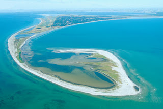
As we can see from that WWI map - there was a small cluster of reefs permanently above water off Falsterbo, labelled Måkläppen; these are the island(s) now connected
since WWII to the main peninsula by a sandbank...but according to those above-mentioned Swedish rules, their four-mile limit...or even the three mile limit...would have been measured from
there, not from the peninsula...
http://www.lansstyrelsen.se/skane/SiteC ... a_2008.pdf
Furthest out in the south-west, the Skåne quadrilateral ends in a strange sand formation, a 5 km long, narrow island arc, best known for its rich bird life. Måkläppen is in principle the country’s oldest nature reserve, as it was placed under protection as early as 1902. In the 1930s Måkläppen, then an island, had an area of only 50x100 metres and lay about 1 km off Nabben. With the continuous shifting of sand, Måkläppen has since increased in size and attached itself to the mainland and is moving northwards.
Twenty years ago we had Johnny Cash, Bob Hope and Steve Jobs. Now we have no Cash, no Hope and no Jobs....
Lord, please keep Kevin Bacon alive...

