State of British Ground Forces, September 1940, Sealion

Discussions on WW2 in Western Europe & the Atlantic.
Post Reply
User avatar
Paul_G_Baker
Member
Posts: 429
Joined: 28 Mar 2012, 17:59
Location: Arundel, UK.

Re: State of British Ground Forces, September 1940, Sealion

#91

Post by Paul_G_Baker » 31 Mar 2015, 00:16

steverodgers801 wrote:googled north sea tide charts got the BBC. ITs not historical but it should be similar. I looked up once the beaufort scale for the north sea and the normal wave height is greater then the barges the Germans planned on using. Trying to relocate http://www.printsplace.co.uk/PS/Store/P ... _WW2-64814 here is a photo and they don't look like they would do to well. http://www.ndbc.noaa.gov/station_page.php?station=62103
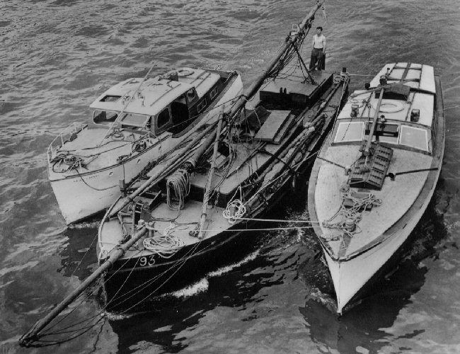
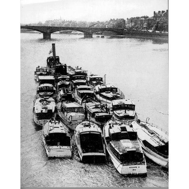
A couple of photos of boats that actually did the Dunkirk run in 1940, Steve. Not very big, are they?

Image

Image

As regards navigation, chalk cliffs should show up fairly well if there's any sort of moonlight; they're white - and therefore somewhat reflective!

First crossing would have the benefit of surprise - probably little to no actual RN in the Straits. Cover of darkness useful to mask approach from shore batteries. Subsequent crossings probably a day-time activity - plan would have been to capture or destroy the batteries soonest. There wasn't much protecting them from assault from the landward side, as far as I know.

@sitalkes: High water at Newlyn (west end of Channel) occurs about 7 hours before High water at Dover - I used to buy/consult tide tables frequently during my Sea-fishing days.
Paul

User avatar
sitalkes
Member
Posts: 471
Joined: 18 Feb 2013, 01:23

Re: State of British Ground Forces, September 1940, Sealion

#92

Post by sitalkes » 31 Mar 2015, 01:40

One of the objections to the Sealion plan was that there was a five hour difference in tides between the two ends of the invasion, but that's for the wide front plan - between Deal and Lyme Regis - I would like to know the difference for the final plan, between Hythe and Newhaven. I'm not sure what relevance modern tide tables have except to show such a difference. I've been looking at the weather in the channel between July and October 1940. and have found some interesting things e.g. the sea state at Dungeness rarely goes beyond 2 and very rarely goes beyond 4; So far I haven't found anything that would rate as a storm (force 10 or better) on the Beaufort scale at Dungeness, and events where the where the wind goes above force 4 are similarly rare - I keep wondering if there's something special about Dungeness and Lympne that reduces the wind strength and sea state.

Before we go off on that silly tack (pun intended!) suggesting the barges couldn't make it, please watch these U-tube videos of barges that are exactly the same as the (smaller type of) invasion barges crossing the English Channel - piloted by tourists in October, no less!
Watch these:

http://www.youtube.com/all_comments?v=ubm4UuGJYyg – the Dutch barge Spica goes through Dutch canals and across the Channel to Portsmouth

65ft barge towed through heavy seas off Dover http://www.youtube.com/watch?v=-kg_QweiLy0
Even in this video the sea doesn't swamp the barge and as the comments say it would not have needed to be rescued if it had a cargo as “50 ton of ballest would have helped the cavitation and steadyed her”

Dutch barge Anna at sea on a trip from Ely to Wisbeach in the Wash http://www.youtube.com/watch?v=7Q6M1z6kS-U

Spits Barge crossing the Channel from Belgium to Leigh on the Thames http://www.youtube.com/watch?v=5X8FXTji5-g

And http://www.youtube.com/watch?v=DGlgvpM-SUU

“Motoring across the channel in our Belgian spits barge 'Madorcha', september 2007, at this point just going over the sandbanks leaving Nieuwpoort Belgium, next anchorage; Liegh small ships, on the Thames. The crossing took us 15 hours, and then another 5 hours to Barking.

Our Belgian spits is standard gauge at 38m x 5.05m, with a 6-71 series detroit diesel/gray marine engine, we averaged 40l of diesel an hour on the sea at full throttle, compared to 20-25l p/h on the inland canals, thats pushing 65 tonnes of ship with 55 tonnes of ballast (125 tonnes gross), only just enough to avoid cavitation with the larger swells.

From Bocholt in Limburg, Belgium to Barking London, we used 1,500l of diesel!.. maybe time to consider a more efficient propulsion system, but the detroit makes a lovely growling scream, with massive torque for 165hp engine.

Proof it's possible to cross with safe precautions, to all the Belgians and Dutch who thought we'd never make it!”

http://www.youtube.com/watch?v=oj0GSuSUAJc and http://www.flickr.com/photos/simoncoggi ... 768054705/ Sailing the Dutch barge Cosmos across the Channel


User avatar
Paul_G_Baker
Member
Posts: 429
Joined: 28 Mar 2012, 17:59
Location: Arundel, UK.

Re: State of British Ground Forces, September 1940, Sealion

#93

Post by Paul_G_Baker » 31 Mar 2015, 02:08

sitalkes wrote:One of the objections to the Sealion plan was that there was a five hour difference in tides between the two ends of the invasion, but that's for the wide front plan - between Deal and Lyme Regis - I would like to know the difference for the final plan, between Hythe and Newhaven.
Look more or less the same: try http://www.bbc.co.uk/weather/coast_and_sea ; click on 'tide tables,' select area then nearest coastal town.
Paul

User avatar
sitalkes
Member
Posts: 471
Joined: 18 Feb 2013, 01:23

Re: State of British Ground Forces, September 1940, Sealion

#94

Post by sitalkes » 31 Mar 2015, 03:01

Well that's interesting, for 31st march it says high tides at Hythe is at 09:31 & 21:48, and at Newhaven it's at 09:38 and 22:06; while for 4th April it is 11:47 & 00:02 at Hythe and 12:12 & 00:29 for Newhaven - that sort of difference would be no trouble at all!! I suppose the time difference grows with the phases of the moon??

pugsville
Member
Posts: 1016
Joined: 17 Aug 2011, 05:40

Re: State of British Ground Forces, September 1940, Sealion

#95

Post by pugsville » 31 Mar 2015, 03:18

"First crossing would have the benefit of surprise - probably little to no actual RN in the Straits. "

hundreds of RN patrol craft in the channel/north sea every night. Barges were under observation, loading would have been easy to spot. Chance of surprise very close to zero.

User avatar
Paul_G_Baker
Member
Posts: 429
Joined: 28 Mar 2012, 17:59
Location: Arundel, UK.

Re: State of British Ground Forces, September 1940, Sealion

#96

Post by Paul_G_Baker » 31 Mar 2015, 03:42

sitalkes wrote:Well that's interesting, for 31st march it says high tides at Hythe is at 09:31 & 21:48, and at Newhaven it's at 09:38 and 22:06; while for 4th April it is 11:47 & 00:02 at Hythe and 12:12 & 00:29 for Newhaven - that sort of difference would be no trouble at all!! I suppose the time difference grows with the phases of the moon??
Far as I can remember, it's purely a function of distance along the Channel. Printed tables (year-per-card or Local paper) came with correction factors for other towns; which, as far as I can recall, were always the same.

For interest, Southampton has either a 'tidal stand' or two periods of High water (whichever way you want to describe it) because of the two sea channels past the Isle of Wight (Low tide, High water, slight drop in level, second period of High water, Low tide).


pugsville wrote:"First crossing would have the benefit of surprise - probably little to no actual RN in the Straits. "

hundreds of RN patrol craft in the channel/north sea every night. Barges were under observation, loading would have been easy to spot. Chance of surprise very close to zero.
According to Fleming, the Invasion Warning Sub-Committee were very reluctant to discard their original assessment of an East Coast landing - even when the build-up of barges was spotted in the Channel Ports. They were quite happy to write barge movements off as 'trade-related' and the stopping of German Army leave as 'something that could happen in any Army'. The 'East Coast Solution' wasn't fully abandoned even when they did come round to the 'Cross-Channel' idea. Not Intelligence's finest hour, if so!

The 'tripwire' scouting force mainly consisted of Lewis-Gun-armed Drifters, carrying rockets to raise the alarm, so it seems.
Last edited by Paul_G_Baker on 31 Mar 2015, 04:07, edited 1 time in total.
Paul

User avatar
sitalkes
Member
Posts: 471
Joined: 18 Feb 2013, 01:23

Re: State of British Ground Forces, September 1940, Sealion

#97

Post by sitalkes » 31 Mar 2015, 03:47

I think surprise would have been hard to achieve, too. However many of the barges did not arrive at their respective embarkation ports until only shortly before the possible invasion dates, so there was constant activity along the coast of barges moving westwards right up to the possible invasion. This was hard for British intelligence to interpret, especially as they thought the landing would be on the east coast, and only changed their mind about that in September. There were also barges and other shipping in the transport fleet practicing embarkation and landing - Manstein says that there were landing exercises going on all the time in the area of his responsibility (once the boats were available). So it's no wonder that the "Cromwell" alert was given when no invasion was happening. The hundreds of patrol craft were spread out along hundreds of miles of coast, and between a third and a half weren't operating at any one time - so it's possible (though you do have to work hard to think up the scenario) that they might miss one or other of the invasion fleets in the night, or that the invasion fleet could sink them before they could fire off their fireworks (they had no radios) or even that nobody sees the fireworks, or misinterprets them if they do. If the Luftwaffe had achieved even some sort of local air superiority, it might also be hard for reconnaissance aircraft to get through to the invasion ports.

By the way, you can download the daily weather reports for 1940 here: http://www.metoffice.gov.uk/archive/9348

Gooner1
Member
Posts: 2792
Joined: 06 Jan 2006, 13:24
Location: London

Re: State of British Ground Forces, September 1940, Sealion

#98

Post by Gooner1 » 31 Mar 2015, 14:20

Going a bit off the topic of the State of British Ground Forces gents ...

Still while we are discussing the Royal Navy ..

'Found some details for the Counter Invasion Methods in Dover Command.
This is dated 30th June 1940.

NAVAL MEASURES.

2. - The detailed measures are laid down in Dover Operation "Napoleon".
These are broadly:-

(a) Destroyer patrols in the Channel, to intercept and engage the enemy at sea, and to support the small craft (b) and (c) below;

(b) Listening patrols of asdic trawlers about 4 miles off-shore to detect the approach of the enemy, to report and attack him;

(c) Inshore patrols of drifters and motor-boats to report and attack the enemy.


3. The methods of reporting the enemy, both by simple firework signal to our forces ashore, and by R/T or W/T to the Flag Officer Commanding Dover.

On 17th September, the patrols following were established and were to be filled as ordered by Flag Officer Commanding Dover.

Patrol - O.D.1. Position - Between N. Goodwin Light Vessel and charted position of South Falls Buoy. Normally Patrolled By - Two or more M/S (MineSweeping Trawlers). Remarks -

Patrol - O.D.3. Position - Between No. 10 buoy and a line drawn 147 degrees from Hastings. Normally Patrolled By - Destroyers. Remarks - Will not be filled concurrently with patrols O.D.6. and/or O.D.7.

Patrol - O.D.5. Position - Between No. 1 buoy and No. 10 buoy. Normally Patrolled By - Destroyers or A/S (Anti-Submarine) trawlers. Remarks - If Destroyers are not available the patrol will be kept by two or more A/S trawlers if available.

Patrol - O.D.6. Position - Between No. 10 buoy and "D" buoy. Normally Patrolled By - Two or more trawlers. Remarks - If O.D.5 is filled by destroyers, A/S trawlers if available, will assist M/S trawlers to fill patrols O.D.6 and O.D.7 (as arranged by Commander A/P and Commander M/S). If A/S trawlers are employed instead of destroyers on O.D. 5, then O.D. 6 and O.D. 7 will be filled with M/S trawlers only.

Patrol - O.D.7. Position - Between "D" buoy and Lydd Light Float. Normally Patrolled By - Two or more trawlers. Remarks - As patrol O.D.6.

Patrol O.E.1. Position - To seaward of the traffic route and northeastwards of a line drawn 135 degrees from Dungeness. Normally Patrolled By - One division of Destroyers. Remarks - Special patrol, if two divisions of destroyers are available in the Command.

Patrol - O.E.2. Position - To seaward of the traffic route and Southwestwards of a line drawn 135 degrees from Dungeness. Normally Patrolled By - One division of Destroyers. Remarks - Special patrol, if two divisions of destroyers are available in the Command.


OBJECT OF PATROLS.

3. The object of the above patrols is :-

(a) To report and attack enemy vessels encountered,
(b) To act in suport of small craft inshore patrols
(c) To prevent enemy submarine, E-boat and mining activity on the traffic route.

SPECIAL INSTRUCTIONS FOR DESTROYERS.

4. The destroyer patrols in particular are stationed with the object of having the ships at sea in the most favourable state of readiness for dealing with any invading force entering or trying to cross the Straits.

5. Attention is called to paragraphs 10 and 11 of Operation "NAPOLEON" but Senior Officers of Units are not to hesitate to use their initiatives as the situation develops.'

I like the emphasis given to "report and attack". Very important to get them that way around of course. :thumbsup:

User avatar
Paul_G_Baker
Member
Posts: 429
Joined: 28 Mar 2012, 17:59
Location: Arundel, UK.

Re: State of British Ground Forces, September 1940, Sealion

#99

Post by Paul_G_Baker » 31 Mar 2015, 15:25

To get firmly back on topic, where did XII Corps' (Lt. General Sir Andrew Thorne) Defence Line run from/to in Kent? Also where were 1st London Div's (Maj General C. F. Liardet) Brigades Headquarted? I understand that XII Corps HQ was in Tonbridge Wells and 1st London Div HQ was in Ashford.
Paul

steverodgers801
Member
Posts: 1147
Joined: 13 Aug 2011, 19:02

Re: State of British Ground Forces, September 1940, Sealion

#100

Post by steverodgers801 » 31 Mar 2015, 20:31

Remember there is not just tides, but wind.

steverodgers801
Member
Posts: 1147
Joined: 13 Aug 2011, 19:02

Re: State of British Ground Forces, September 1940, Sealion

#101

Post by steverodgers801 » 31 Mar 2015, 20:37

Also comparing the boats to barges, the German ones don't look designed for high waves. Size is not important for just tides, but when wind is factored in then having the insides enclosed is critical and I just don't see that in the German barges. here is a weather report that includes wind factors http://windalert.com/spot/51752 notice that its as high as 14 feet.

User avatar
sitalkes
Member
Posts: 471
Joined: 18 Feb 2013, 01:23

Re: State of British Ground Forces, September 1940, Sealion

#102

Post by sitalkes » 01 Apr 2015, 00:31

Re: Dover Patrol - that's a nice find, however perhaps it should be pointed out that shortly after those orders were written, Dover Command had no destroyers under its command as they all had to be sent away to Portsmouth or the Nore due to attacks by German aircraft.

Re: wave height. 14 feet with the wind strength at 52 mph? that's a force 9 gale, which is not recorded as happening at Dungeness at anytime between May and October 1940. Highest strength wind recorded there in 1940 (a time when people remarked about the wonderful, unusually good weather) was a force 8 gale, and even for that you have to go to the last days of October or November/December. The worst it got in September was Force 6 on the 17th, and even then the sea state doesn't get worse than 4. At any rate -although everybody agrees that unloading across beaches would have been impossible in bad weather so bad weather would have impeded the transfer of supplies - it's silly to talk about barges crossing/invading in storms, since it would not have been done - unless you think the Germans had a "cunning plan" to do so, since nobody would be stupid enough to do that? As I said , watch the videos, the barges could cross under normal weather conditions. At other times, it would have only been possible to use the transports between ports, though there was enough port capacity available in the landing area only for the first wave - once the second wave arrived, the Germans would have had to capture a major port like Southampton or they would not have been able to provide enough supplies to their troops during bad weather (during good weather they could still use the beaches, which could take more than the ports).

Re: location of forces. Below is a map showing the stoplines in SE England - strictly speaking there was no defence line occupied by those troops (either they were on the coast or inland prepared for counter-attack) but one supposes that any defence line they used would have been one of these
Beaches and fortifications map SE England.png
Stop lines in SE England
Beaches and fortifications map SE England.png (456.04 KiB) Viewed 1076 times
Re: Tides - you are supposed to be able to get a free three month use of Admiralty Total Tides from URL: FTP://ukho.gov.uk
Username: ukhopublic
Password: Public12345
However my computer won't load the ftp page. There are also some apps for smartphones, but I have the wrong sort of phone for that.

steverodgers801
Member
Posts: 1147
Joined: 13 Aug 2011, 19:02

Re: State of British Ground Forces, September 1940, Sealion

#103

Post by steverodgers801 » 01 Apr 2015, 08:33

Normal weather, should be abnormal weather. Could the Germans really count on the weather cooperating enough. Just image a storm like the one that hit impeding German supply. Even with out a major storm, I wonder how effective a crossing in those barges could be unless given perfect weather

User avatar
Paul_G_Baker
Member
Posts: 429
Joined: 28 Mar 2012, 17:59
Location: Arundel, UK.

Re: State of British Ground Forces, September 1940, Sealion

#104

Post by Paul_G_Baker » 01 Apr 2015, 13:48

Re: Wave heights - We've just had two days of Weather Alerts for Strong Winds (from a Northerly direction) but this site:- http://magicseaweed.com/UK-Ireland-Wave-Buoys/1/ shows that the Channel never got up above 9 ft. Even that was at the Sandettie Light Vessel - moored in open water, North of Calais - and didn't last for long. Folkstone and Deal readings did not exceed 4.5 ft, as far as I saw.

Re: Location of forces/defences - According to my understanding of Macksey, 1st (London) Div (in July 1940) had the job of counter-attacking at Hawkinge, Manston and Lympne airfields as well as backing up local forces in the 'Coastal Crust'. I'm pleased to see that there are defences between the Graveney and Chislet Marshes (roughly, Reculver to Whitstable) as that's where he claimed the 'Corps Line' had been laid down.

Artillery assets Macksey cites (page 60) as belonging to 1st (London) Division in early/mid July 1940 were:-

64th Field Regiment (at Richborough);
2 x13pdr
2 x 4.5in Howitzer
4 x 25pdr

90th Field Regiment (at St Nicholas-at-Wade)
2 x13pdr
4 x 18pdr
4 x 25pdr
2 x 4.5in Howitzer

113rd Field Regiment (at Whitstable)
2 x 18pdr
4 x 4.5in Howitzer

C4 Mobile Battery (at Godinton - just to NW of Ashford)
2 x 12pdr
2 x 3pdr

C5 Mobile Battery (at Godinton - just to NW of Ashford)
4 x 4in

X Static Battery (near Ashford)
4 x 4in

Re: the Superheavy Guns listed above.... Look impressive in terms of calibre (and the bang at either end of the trajectory) but would their efforts have been reported as anything worse than 'harassing fire'? That's the problem with weapons firing 380lb and 750lb shells... rate of fire tends to be rather low.
Paul

User avatar
sitalkes
Member
Posts: 471
Joined: 18 Feb 2013, 01:23

Re: State of British Ground Forces, September 1940, Sealion

#105

Post by sitalkes » 01 Apr 2015, 14:42

Well none of videos show crossings in perfect weather; the weather didn't have to be perfect, just good enough to allow the crossing would do. Normal weather varies for the time of year, so yes the Germans can rely on having mostly good weather in the summer and early autumn but from the end of October they can expect mostly bad weather. If they had crossed on 23/24 September they could expect a few days of good weather only (enough for the 1st, 2nd, and part of the 3rd echelons of the first wave) but the whole enterprise was extremely risky anyway and similar risks had not stopped them in the past. The weather on 28 September might upset their timetable but although the intervening weather isn't perfect, there isn't another seriously bad day until 5/6 October (force 6 winds).

Post Reply

Return to “WW2 in Western Europe & the Atlantic”