Attached is a quickie image of one of the three Toungoo area aerial photographs from 1944 that I received from the National Archives yesterday. The photo has the northwestern corner pointed towards the top.
Some points:
1) it is obvious that what I thought was the city wall from the Google satellite photo was not the wall itself, but the moat. The wall itself is much harder to see. Moreover, it is much more ruined than I thought it was. I did some more research into the wall and discovered that it was in a very ruined state as early as the 19th century. What was done was that the moat was dug, then the earth placed BEHIND the brick wall as a sort of earthen rampart sloping down from the wall to the ground. This actually reinforced the wall considerably and, unknown of course to its centuries-earlier builders, made it resistant to gunpowder/cannons. This allowed the wall to be much more effective than other similar square walls without a corresponding buttress. It also makes claims that the Japanese "breached" the wall unlikely, as it was not just a wall they would have to get rid of, but basically a hill of earth as well.
2) this photo was taken at a different time of year than March-April, and appears to be far wetter than the terrain would appear during the dry season. Other photos, showing more of the surrounding terrain, make this more clear.
3) The interior of the old town is less crowded/congested than I thought it would be. We know the Chinese destroyed part of the city in preparation for its defense. I had thought initially this would be part of the city outside the wall, to clear fields of fire for fighting from the wall, but that was back when I thought the wall was more intact than it was. Looking closely at the photo of the old town, it looks like there are areas of cleared rubble in the southeast section. I wonder if this was part of the city destroyed by the chinese. If so, I wonder what was there before?
4) the British fort is in the far southeast corner of the map; this probably would have still been a good defensive bastion for the Chinese. The railroad separates it from the rest of the town. To the west of the fort is the railroad station.
5) I don't know what that large interesting building is near the northeast corner of the map. It is not the old palace, which was in the center of town.
6) that's a big pond/small lake in the sw corner of the map, created originally by the town's founders for a secure water supply.
7) in this photo, parts of the moat have water, other parts are marshy. This is apparently still the case today, although I have noticed Burmese plans for fisheries in the moat.
Chinese 200th Division: descriptions of actions needed!
-
Edward Chen
- Member
- Posts: 87
- Joined: 28 Nov 2005, 17:27
- Location: New York City
Hi all,
Just wanted to add the following to the discussion, since as the cliche goes, "a picture is worth a thousand words."
/////
General Tai An-lan (1904-1942)

This more famous photo of the general is on display in the Martyr's Shrine [Zhong Lieci], Taipei, Taiwan.

General Tu Yu-ming (1904-1981)
This 1932 family photo shows (right to left) the general, his wife Tsao Hsiu-ch'ing, and daughter Tu Chih-li (1927-2003).
Tu Chih-li was famous for her marriage to the Chinese-American Nobel prize-winning physicist Yang Chen-ning (1922-).

Group portrait of senior Nationalist commanders in the China Expeditionary Army sent to Burma.

Front row from right to left: Tu Yu-ming, Hsu Ting-yao [Xu Tingyao; the "father of the Chinese Armored Force"], and Huang Chieh [Huang Jie; 1902-1995]. Back row: Ch'iu Ch'ing-ch'uan [1902-1949], Cheng Tong-kuo [Zheng Dongguo; 1903-1991], and Liu Chia-shu [Liu Jiashu; 1903-1972].
General Lo You-lun (1905-1994)

General Lo was officially recognized as the fourth superintendent of the Central Military Academy of the Republic of China Armed Forces, and the first one since it was set up in Fengshan, Taiwan.
Just wanted to add the following to the discussion, since as the cliche goes, "a picture is worth a thousand words."
/////
General Tai An-lan (1904-1942)
This more famous photo of the general is on display in the Martyr's Shrine [Zhong Lieci], Taipei, Taiwan.
General Tu Yu-ming (1904-1981)
This 1932 family photo shows (right to left) the general, his wife Tsao Hsiu-ch'ing, and daughter Tu Chih-li (1927-2003).
Tu Chih-li was famous for her marriage to the Chinese-American Nobel prize-winning physicist Yang Chen-ning (1922-).
Group portrait of senior Nationalist commanders in the China Expeditionary Army sent to Burma.
Front row from right to left: Tu Yu-ming, Hsu Ting-yao [Xu Tingyao; the "father of the Chinese Armored Force"], and Huang Chieh [Huang Jie; 1902-1995]. Back row: Ch'iu Ch'ing-ch'uan [1902-1949], Cheng Tong-kuo [Zheng Dongguo; 1903-1991], and Liu Chia-shu [Liu Jiashu; 1903-1972].
General Lo You-lun (1905-1994)
General Lo was officially recognized as the fourth superintendent of the Central Military Academy of the Republic of China Armed Forces, and the first one since it was set up in Fengshan, Taiwan.
Just curious as whether there are aerial photographs of Chinese cities during the 1937-45 period in the US National Archives holdings and how does one go about searching for this stuff.pitman wrote: If luck holds, my aerial photographs of Toungoo (from 1944) from the U.S. National Archives should be at my mailbox when i get home today. This includes printed and digital versions. If so, I will try and shrink one of them to post-able size and post it here.
It is possible that there are aerial photographs of Chinese cities during the 1937-1945 period in the U.S. National Archives, though I would think it is not likely.
One possible source would be captured Japanese aerial photographs. I really don't know how much the U.S. possessed, but I think it is not much.
The other source that would be in the National Archives would be allied aerial photographs. But for the U.S. in China, most of its aerial reconnaissance probably would have been directed at Japanese cities and targets for its China-based bombing campaign. I don't think they did much strategic or operational bombing in China to support the KMT. So I think the odds are slim.
However, there is no harm in inquring. I have always found the folks at the National Archives to be helpful in their responses.
See http://www.archives.gov/research/order/maps.html#info
I'm curious if anybody has any detailed information about the role the 200th Division played at Kunlun Pass in Dec 1939 to Jan 1940? I have read a number of on-line Chinese-language accounts of the battle, using on-line translators, but they are basically just overviews and only treat the 200th Division in a sentence or two.
I am also interested in pictures of the battlefield or terrain in the area, so I can get a picture of what terrain they were fighting over. I have seen photographs of the Kunlun Pass memorial, but not the pass itself, or the various ridges and hills that were fought over.
Any assistance would, of course, be greatly appreciated.

Look here for WWII China topo maps:
http://www.lib.utexas.edu/maps/ams/china/
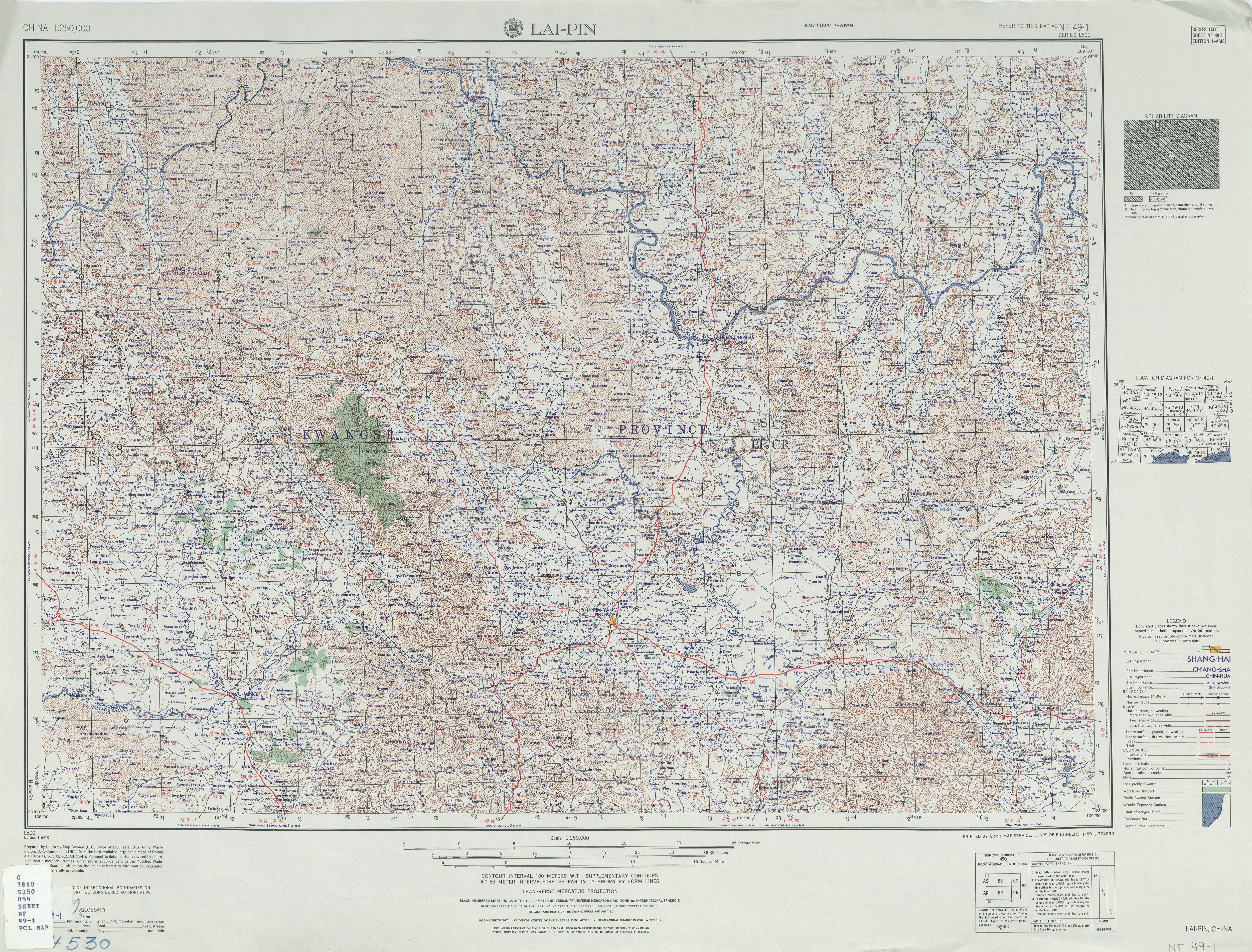
This map has the pass just above where the road from Nanning enters the map
http://www.lib.utexas.edu/maps/ams/chin ... nf49-1.jpg
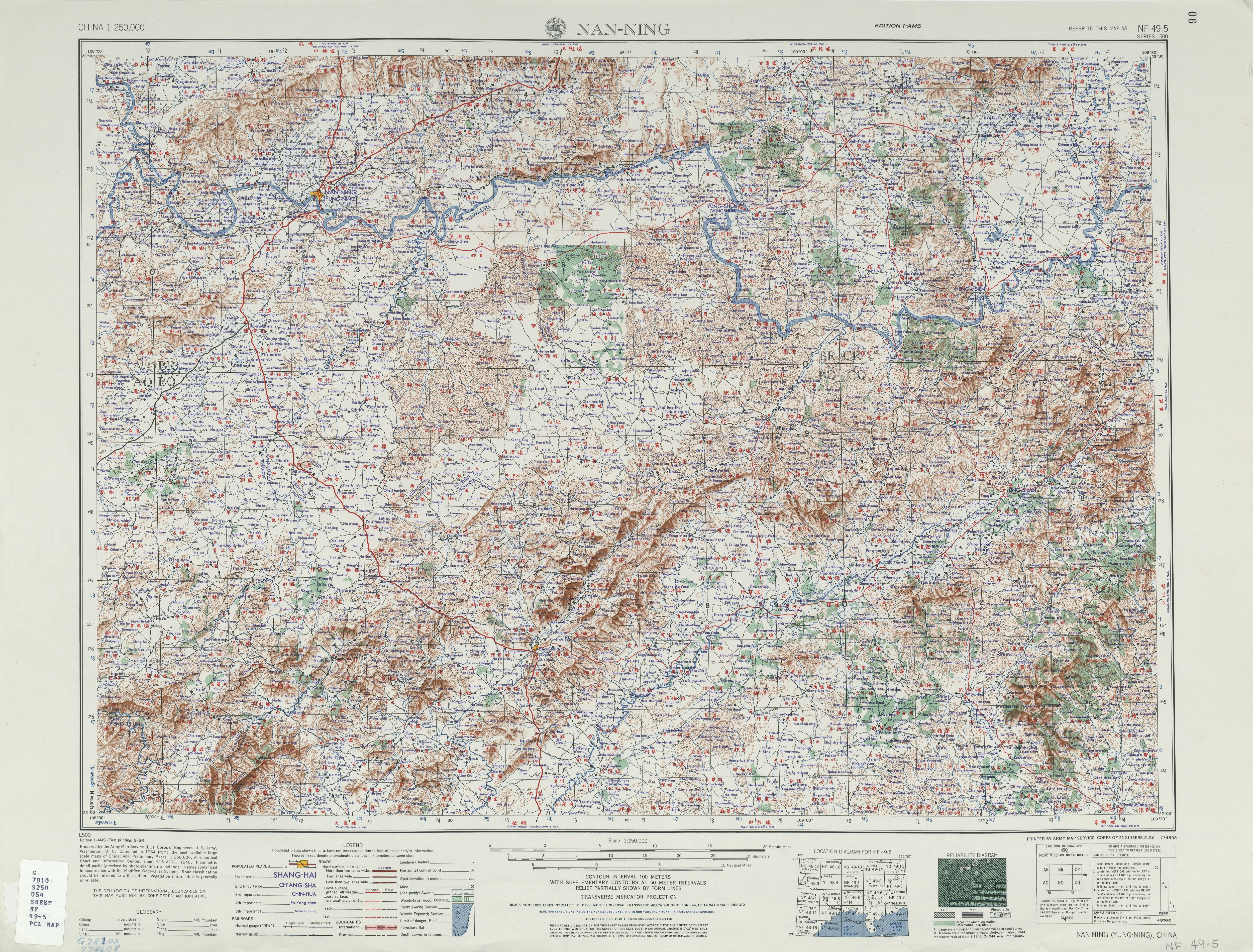
Nanning area.
http://www.lib.utexas.edu/maps/ams/chin ... nf49-5.jpg
These two cover the area where most of the fighing went on in the Guangxi campaign.
http://www.lib.utexas.edu/maps/ams/china/
This map has the pass just above where the road from Nanning enters the map
http://www.lib.utexas.edu/maps/ams/chin ... nf49-1.jpg
Nanning area.
http://www.lib.utexas.edu/maps/ams/chin ... nf49-5.jpg
These two cover the area where most of the fighing went on in the Guangxi campaign.
I have been looking into the role of the 200th Division at Kunlun Pass. To my surprise the description is rather sparse, particularly when compared to the Battle of Toungoo, although Kunlun Pass was hailed as an important victory by the KMT. I think a major reason for this is that the 200th D was responsible for the initial assault, which did not went too well, and the decisive thrust was provided by another division. I will have my hands on the full Chinese translation of the Senshi Sosho account of the battle soon, and I can hopefully post a composite account based on both the Chinese and Japanese views.pitman wrote:I'm curious if anybody has any detailed information about the role the 200th Division played at Kunlun Pass in Dec 1939 to Jan 1940? I have read a number of on-line Chinese-language accounts of the battle, using on-line translators, but they are basically just overviews and only treat the 200th Division in a sentence or two.
I think I was the first person to post Google earth satellite photographs in this thread, so I have not forgotten that option.pitman wrote:asiaticus wrote:To get an idea of the vegetation coverage use Google Earth satilite photos.
Of course, that was 60+ years ago, and Google Earth also cannot get down to a fine resolution, and, of course, I still have no idea which patches of ground precisely were fought over. Which is why I asked if anybody knew of photographs of the terrain on which the battle took place.
That would actually be extremely interesting! I hope you can find the time to do so. Thanks very much in advance. It seems like an extremely interesting battle.sjchan wrote:I have been looking into the role of the 200th Division at Kunlun Pass. To my surprise the description is rather sparse, particularly when compared to the Battle of Toungoo, although Kunlun Pass was hailed as an important victory by the KMT. I think a major reason for this is that the 200th D was responsible for the initial assault, which did not went too well, and the decisive thrust was provided by another division. I will have my hands on the full Chinese translation of the Senshi Sosho account of the battle soon, and I can hopefully post a composite account based on both the Chinese and Japanese views.
These maps are really hard to read. I dont't think Kunlun Pass itself is marked, it's the little kink in the road at the spot noted by asiaticus.asiaticus wrote:The pass is on the Nanning - Pin Yang road just north of Chiu t'ang tsu (with the Red Arrow) on map NF49-1.
The Senshi Sosho account is very detailed, some 35 pages; need time to digest and translate. The following map regarding the battle on Dec 18, which shows the pass (circled in blue), Chiu t'ang at the bottom (circled in red) and the heights surronding the pass, is taken from Senshi Sosho, which also provides the following information regarding the terrain. Some key high grounds: Jieshou (circled in green), Luotang (purple), Baisheng (orange) and Triangular Hill (brown).
The region north of Nanning, including Kunlun Pass, consists of hills between 300-500 m. Vegetation covers hillsides beneath 400m, above that are primarily barren slopes which are easily observable. Along the main road from Nanning are a series of hamlets; they are really small e.g. Chiu T’ang houses only about 40 families. Kunlun Pass dominates the main road, and is itself dominated by Point 653 to the east, Point 445 and 441 to the west. On Dec 17, 1939, sunrise was at 0830, and sunset 1920. Visibility was about 200m.
- Attachments
-
- klpj18z.jpg (249.21 KiB) Viewed 24136 times
Last edited by sjchan on 05 Nov 2007, 13:24, edited 1 time in total.