Need help for id. Battle-places in East Africa

Discussions on all aspects of the German Colonies and Overseas Expeditions. Hosted by Chris Dale.
Post Reply
User avatar
Tanzania
Member
Posts: 930
Joined: 04 Jun 2009, 14:59
Location: Benghazi / Libya

Need help for id. Battle-places in East Africa

#1

Post by Tanzania » 06 Mar 2022, 18:55

Need help for id. Battle-places in East Africa

Currently I search for the exact location of Battle places in Portuguese East Africa (Moçambique)

Battle at Kireka-Berg – 5th May 1918 in PEA

Mozambique: Rosecol takes over Pamforce advance. Action of Nanungu in Kireka Mountains (30 miles
west of Koronje and 160 miles south of Lake Nyasa): Lettow’s 404 men (107 casualties) beat c.800 KAR
from NRFF (c.211 cas including 106 PoWs), but both sides retire during night (until May 8).

Textual Source: https://www.ww2-weapons.com/diary-may-5-1918/
Both positions are nonsense! “. . . 160 miles south of Lake Nyasa”, would be south of Blantyre in Malawi.


01_Overlook Map_Portuguese East Africa with Kireka Berg
01_Overlook Map_Portuguese East Africa.png
01_Overlook Map_Portuguese East Africa.png (344.78 KiB) Viewed 8060 times
Original Source: Kartenbeilage “KRIEGS-SAFARI” Richard Wenig, Berlin, 1920


02_Detail sketch for Battle at the Kireka-Berg 5.5.1918
02_Detail sketch for Battle at the Kireka-Berg 5.5.1918.jpg
02_Detail sketch for Battle at the Kireka-Berg 5.5.1918.jpg (57.52 KiB) Viewed 8060 times
Source: https://www.allworldwars.com/image/153/ ... eck-23.jpg

The War Office Archive offers a wide range of old Military maps; - many based on captured German detail maps!
PEA Maps on British Library Website – WOMAT/AFR/BCA/15
(Select and push on of the red button, and afterwards on the left side, the middle (second from top) link.)
https://www.google.com/maps/d/viewer?mi ... 345634&z=8


This is my personal favourite map, but where is the Kireka-Berg or Mountains TODAY?
03_Map without Kireka Berg
03_Map without Kireka Berg.png
03_Map without Kireka Berg.png (622.83 KiB) Viewed 8060 times
Original Source: http://www.bl.uk/manuscripts/Viewer.asp ... !2!1_f001r

Any idea?
“Day by day and almost minute by minute the past was brought up to date. . . . All History was a
palimpsest, scraped clean and reinscribed exactly as often as was necessary” – G. ORWELL 1984

User avatar
danebrog
Member
Posts: 397
Joined: 17 Nov 2008, 16:59

Re: Need help for id. Battle-places in East Africa

#2

Post by danebrog » 07 Mar 2022, 01:12

Because obviously everyone enters the place names just as it suits him and your favorite map also has no scale, I had to roughly interpolate.
The approximate distances based I have then adopted the topography on Google maps and this is my best "guesstimate"
On a gut feeling, I would guess the long ridge just above Colia.
AHF.jpg
AHF.jpg (73.68 KiB) Viewed 7880 times
Now you "only" need a reasonably detailed map of the Maúa district and a local guide, and Voila.....
(Well, a tiny little bit more difficult it might be ) :lol:


User avatar
Tanzania
Member
Posts: 930
Joined: 04 Jun 2009, 14:59
Location: Benghazi / Libya

Re: Need help for id. Battle-places in East Africa

#3

Post by Tanzania » 09 Mar 2022, 20:01

danebrog wrote:
07 Mar 2022, 01:12
Because obviously everyone enters the place names just as it suits him and your favorite map also has no scale, I had to roughly interpolate.
The approximate distances based I have then adopted the topography on Google maps and this is my best "guesstimate"
On a gut feeling, I would guess the long ridge just above Colia.
AHF.jpg
Now you "only" need a reasonably detailed map of the Maúa district and a local guide, and Voila.....
(Well, a tiny little bit more difficult it might be ) :lol:
You were right with your interpolation measures insofar as the Kireka-Berg is near the centre of your red ellipse.
I was also able to go a little further and narrow the circle further; - but it took a while.


But the Russians also couldn't help with their old maps, despite the Cyrillic-German online translation:
Mir 1:500.000 - D-37-1 (D-37-A) Maua - (ju.p.) [Südliche Himmelsphere]
https://www.landkartenarchiv.de/vollbil ... ?q=xd-37-1
At least the main track route in the 80s, from Nanungu / Nungo to Mahua / Maúa, could be compared
on this old map, so that the following positions should be considered safe. (Ten years ago the Russian
Africa maps were available in scale: 1 : 200,000 and parts even down to 1 : 50,000; - why not today?)


On this map from 1929, with additions from 1939 (!), the positioning is not correct at all. Here, Nanungu /
Nungo is even more southerly than Mahua. Only the Msalu River appears here, as on map 02 and 03.
MAHUA Sheet SD 37-1: https://maps.lib.utexas.edu/maps/ams/ea ... d-37-1.jpg


Below a further very good overlook map about whole Northern PEA & Southern GEA from a British perspective:
Map of Central & East Africa – Norforce 1915-1918 – Scale 1:2,000,000 (with a very high resolution!)
Article Source: http://catalog.afriterra.org/viewMap.cmd?number=3739
Direct map Link: http://catalog.afriterra.org/zoomMap.cmd?number=3739


04_Nanungu Area – Portuguese East Africa – Scale: 1:500,000
1918, Covers an area of approximately 60 miles radius around Nanungu in north-eastern Portuguese
East Africa. Portrays hydrology, relief by form lines, roads and tracks, settlements and place names.


In addition to a scale, the map below, even shows the marching performance in hours and distance! Even if the position
of Nanungu / Nungo and Mahua does not yet quite correspond to today’s locations, the affiliation to Sketch 02 can be
very clearly understood and thus limited by names. Possibly the native name of Mwamba Hill below Makoti / Nakoti
corresponds to the German Kireka-Berg. The name Kireka-Mountains, which is also used by the British, was probably
not yet included in this lower map. However, names appearing in texts and sketches have been marked in light green.

04_Nanungu Area – Portuguese East Africa – Scale 1-500,000.png
04_Nanungu Area – Portuguese East Africa – Scale 1-500,000.png (682.58 KiB) Viewed 7260 times
Original Source: http://www.bl.uk/manuscripts/Viewer.asp ... !3!1_f001r


On the map above, the approximate 15 miles, between Nungo / Nanungu and Nakoti / Makoti and Mount Kireka,
should correspond to the 24 kilometres on the link on this Google map below.
https://www.google.de/maps/dir/-13.4064 ... e0!5m1!1e4

Will be continued . . . .
“Day by day and almost minute by minute the past was brought up to date. . . . All History was a
palimpsest, scraped clean and reinscribed exactly as often as was necessary” – G. ORWELL 1984

User avatar
Tanzania
Member
Posts: 930
Joined: 04 Jun 2009, 14:59
Location: Benghazi / Libya

Re: Need help for id. Battle-places in East Africa

#4

Post by Tanzania » 12 Mar 2022, 09:21

In Portuguese East Africa, the `Schutztruppe´ rarely moved as a homogeneous body, but was divided into
several Detachments, some of which operated completely independently and self-sufficiently for weeks. The
Detachments, in turn, had constantly sent out combat-, reconnaissance- and hunting-patrols, sometimes also
for months. The composition of these Detachments also changed constantly; - partly only with two companies
and days later five companies strongly. There are enough examples where units occupied a fortified place
after a fight and withdrew after two days, which was then occupied by the opponent, only to be subsequently
reconquered by their own units. This circumstance makes it particularly difficult to trace and document the 10-
month campaign in Portuguese East Africa in detail, because the situation for all involved changed often daily,
sometimes hourly. This also applies to the battles and events around the Kireka-Berg.

With the many different names used for one and the same locality, rivers and the so-called 'Insel-Berge' in
PEA are the only unchanging components. The personal notes of Lettow-Vorbeck, Boell, Goering, Wahle,
Koehl and others are helpful for further localization. In these historical records, Nanungu is mentioned at the
same time as Kireka Mountain. It was also shown in Battle Sketch 02 that there was a Nanungu (settlement)
as well as a Nanungu Boma. How helpful such a textual landscape description can be, is shown by Sec. Lt.
Richard Wenig
example below for determining the location of Nanungu Boma.

. . .On March 6, 1918 I marched past high, jagged rock mountains through rich, well-built fields of the
locals towards a rugged, pointed cone, at the foot of which lies Nanungu Boma.
[ . . . ] I turn a little to
the south and choose as a camping place the gently rising, with high trees existed slope of the pointed,
not two hundred meter high Rock Mountain of Nanungu. In addition to my battery, General Wahle, the
Master of Arms, and several columns are located there.
[ . . . ] These days I am often with Ruckteschell,
who let build a grass house high up on the Nanungu Mountain, to spend a short time there for his rest.
He returned two days ago from a long-distance patrol with only 20 Askari for more than three months.


05_Aerial perspektive of Nanungu Peak and Boma.png
Source: Google Earth Pro Aerial perspektive

Goggle position: https://www.google.de/maps/@-13.3846606 ... e3!5m1!1e4

Will be continued . . .
Cheers Holger
“Day by day and almost minute by minute the past was brought up to date. . . . All History was a
palimpsest, scraped clean and reinscribed exactly as often as was necessary” – G. ORWELL 1984

User avatar
Tanzania
Member
Posts: 930
Joined: 04 Jun 2009, 14:59
Location: Benghazi / Libya

Re: Need help for id. Battle-places in East Africa

#5

Post by Tanzania » 20 Mar 2022, 19:48

danebrog wrote:
07 Mar 2022, 01:12
. . . Well, a tiny little bit more difficult it might be ) :lol:
Not because things are difficult, we do not dare them, but because we do not dare them, they are difficult.
(Lucius Annaeus Senecahttps://simple.wikipedia.org/wiki/Seneca_the_Younger)


06_Topographic Map of Marrupa District, Niassa Province, Mozambique
06_Topographic Map of Marrupa District, Niassa Province, Mozambique.png
Original Source: (Full screen & Zoom) https://elevation.maplogs.com/poi/niass ... 55296.html
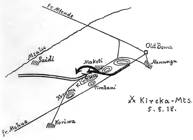

On April 4th, 1918, Lt. Col. Charles Barton had occupied with three companies of the 3. Bat./1. Rgt. K.A.R. Mahua
and proceeded with the advance on the Main track to Nanungu Boma. On April 11th, the 4. S.- and 2. F.-Company
under Sec. Lt. Erich Müller attacked these units at Kirowa and pushed these opponent companies back on Mahua.
Two machine guns with 6000 rounds were captured.

Meanwhile, the 2. Bat. /1. Rgt. K.A.R. also advanced towards Nanungu from the northwest, but was stopped by
Maj. Gen. Edward Northey on April 21th, 1918 and were used to reinforce the 3./1. K.A.R. at Mahua, while further
1 1/2 K.A.R. Battalions followed and advanced also towards Nanungu from the northwest. At the same time the two
companies of `Detachment Müller´ had made a foray against the British rear communications north-east of Mahua,
and had taken the post at Kanene. Here, 460 loads of food were captured, which were particularly valuable in view
of the feeding problems of the `Schutztruppe´ and which led to further delays on the advances of the opponent.

While on 26th April 1918 the 1./2. K.A.R., started together with the first parts of the 1. R.N.R. to march to Nanungu
from northwest positions, Lt Col. Barton also advanced the next day with 2./1. and 3./1. K.A.R. from Korewa to the
north-eastern Nanungu, however, marched not on the main road to Nanungu, but on north-western native paths.
After the 2./1. and 3./1. K.A.R. came into contact with a German patrol during the advance on May 3th, west of the
Kireka Mountain, Lt. Col. Barton set up a circular fortification at Makoti on May 4th, and only began to advance to
Mopelia on the morning of May 5th.

In the meantime, the Commando had received message from the patrols about the opponent at Makoti and had left
Nanungu on May 4th. At noon the next day, Lt. Col. Paul von Lettow-Vorbeck, attacked the opponent north of Kireka
Mountain with five companies (9.-, 10.-, 14.-, 19.- and 21.- Field Companies) and threw him back on his fortification.
Due to double strength, however, it was not possible to throw the British opponent out of his fortified position despite
being surrounded on both sides. Lt Col. Lettow-Vorbeck then withdrew his companies during the night. Lt. Col. Barton
also ordered his units to withdraw back to Kirowa, but had to leave his battlefield-hospital with 100 seriously wounded.

Although both opponents had lost 25% of their combat strength, Lt. Col. Lettow-Vorbeck managed to keep the opponent
away from Nanungu for another 2 weeks. A far-reaching success, however, was that Lt.-Gen. Jacob L. van Deventer
made the big mistake of assuming the `Schutztruppe´ would march north again. All units were therefore drawn in a
semicircle around Nanungu to prevent escape. The British proceeded so slowly that Nanungu was not occupied until
the evening of May 19th, 1918, while the Schutztruppe had been on their way south for three days, meanwhile the 4./4.
K.A.R. are fishing at the Msalu River. https://digitallibrary.usc.edu/asset-ma ... 1600&H=757


07_Transferred current geographic conditions based on the 02_battle sketch
07_Transferred current geographic conditions based on the 02_battle sketch.png
Original Source AllTrails: https://www.alltrails.com/de/explore?b_ ... 9781516792
“Day by day and almost minute by minute the past was brought up to date. . . . All History was a
palimpsest, scraped clean and reinscribed exactly as often as was necessary” – G. ORWELL 1984

Post Reply

Return to “German Colonies and Overseas Expeditions”